Felipe is a community and spatial ecologist focusing on how spatial structure influences biodiversity and related ecological processes. In his research, he studies the effects of anthropogenic landscape structures on different facets of biodiversity, including taxonomic diversity, functional diversity and beta diversity. Currently, he also seeks to use the multidimensionality of biodiversity to gain insights into natural capital biological assets, both in pristine and recovering natural areas. Felipe has also developed computational spatial modelling tools for nature recovery, including the simulation of ecological corridors and the identification of priority areas for restoration and conservation.
He is currently an ecological remote sensing postdoctoral researcher at the University of Oxford, funded by Leverhulme Centre for Nature Recovery, where he is working on the use of Earth Observation data to map aspects of ecosystem functionality and resilience, and to assess the temporal dynamics of land use and land cover change in areas dedicated to nature recovery.

Related Toolkits

Artificial Intelligence
Developing AI algorithms to monitor, predict, simulate and contrast the baseline change in nature with the impact of interventions.

Remote Sensing
Working across pristine and human modified temperate and tropical forest ecosystems to understand and generate new knowledge about their functionality, health and resilience.
Related Projects

Understanding nature recovery paths and ecosystem functioning through forests health assessments
Quantifying the health of forests ecosystems by means of earth observation can aid in understanding nature recovery paths and ecosystem functioning
Mapping nature recovery at scale
Our AI team is developing state-of-the-art AI approaches to combine different sources of data, including drones, satellite, survey data and social media, that are robust to a range of environmental scenarios, data noise and model reliability.

Social ecological mapping for nature recovery
Developing social ecological maps for land use planning, investment and inclusive decision-making.
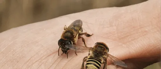
Remote sensing approaches to characterise pollinator diversity and plant-pollinator interactions in nature recovery landscapes of Eastern Ghana
Evaluating the effects of nature recovery on pollinators their interactions with plants.