
Remote sensing Toolkit
Working across pristine and human modified temperate and tropical forest ecosystems to understand and generate new knowledge about their functionality, health and resilience.

About
We work across pristine and human modified temperate and tropical forest ecosystems to understand and generate new knowledge about their functionality, health and resilience. We contribute knowledge and tools for biodiversity positive and nature based solution analyses and aim at Increasing the positive impact of Earth Observation and ecological knowledge for evidence based policy making at local and global scale.
There is a tremendous need for understanding the state of our natural ecosystems. This need has been exacerbated due to the known decline in biodiversity and natural resources, in part due to Land use conversion, degradation of land and Ocean systems and climate change.
Although it is widely known that the terrestrial and ocean ecosystems are changing and tools have been developed to try to quantifying those changes we are still facing a lack of tools and indices that allow us to go beyond quantifying number of species, fragments, sizes and other spatial components towards finer structural, morphological and chemical aspects. Developing knowledge about the above highlighted aspects can improve our understanding about the processes of nature recovery and health of our ecosystems the process of nature recovery the process of nature recovery at small and large spatial extents.
We use Remote Sensing and in general Earth Observation as the science that quantifies aspects of an ecosystem without being in direct contact with it. Up to now we have mostly used remote sensing products to quantify discrete aspects of local and global areas, such as counting the number of fragments in a landscape, its connectivity, distance between fragments and sizes, and for characterizing land use and quantifying its changes. Besides generating those common landscape metrics we are also using satellite and UAV (unmanned aerial vehicles) remote sensing to bring a novel understanding on the structure, morphology and chemistry of land ecosystems across space and time. With our new approaches we are gaining a new understanding on ecosystem health, their paths to recovery and their resilience to global environmental change.
We use multi/hyperspectral and vegetation structure from LIDAR (light detection and ranging) sensors mounted in drones which imagine the landscapes at extremely high spatial and spectral resolution of a few centimetres. We also make use of state of the art satellite earth observation to extrapolate our local findings to the regional and global extents. We are currently specially working with the Copernicus constellation of Sentinel satellites from the European Space Agency (ESA) and the Landsat satellites and GEDI LiDAR (Global Ecosystem Dynamic Investigation) missions from NASA.

Projects


Theme outputs
- Remote sensing
- Scale and Technology
- Society
- Remote sensing
- Scale and Technology
- Society
Jesús Aguirre-Gutiérrez, Sandra Díaz, Sami W. Rifai et al. (2025). Tropical forests in the Americas are changing too slowly to track climate change. Nature.
Species are expected to shift their ranges as the climate changes, but shifts may not occur fast enough, especially for immobile species such as plants. Two papers in this issue assess the degree to which plant species are tracking climate change in the American tropics, where data availability has constrained inference. Ramírez-Barahona et al. show that in Mesoamerican cloud forests, climate change and deforestation together have led to a mean upward shift in species ranges since 1979, mainly due to contracting lower range edges. In tropical forests across the Americas, Aguirre-Gutiérrez et al. found that tree traits are not shifting fast enough to track climate change based on trait-climate relationships, with smaller shifts in montane forests
Jesús Aguirre-Gutiérrez, Sami W. Rifai, Xiongjie Deng, Hans ter Steege, Eleanor Thomson, Yadvinder Malhi, et al. (2025). Canopy functional trait variation across Earth’s tropical forests. Nature.
Tropical forest canopies are the biosphere’s most concentrated atmospheric interface for carbon, water and energy. However, in most Earth System Models, the diverse and heterogeneous tropical forest biome is represented as a largely uniform ecosystem with either a singular or a small number of fixed canopy ecophysiological properties. This situation arises, in part, from a lack of understanding about how and why the functional properties of tropical forest canopies vary geographically4. Here, by combining field-collected data from more than 1,800 vegetation plots and tree traits with satellite remote-sensing, terrain, climate and soil data, we predict variation across 13 morphological, structural and chemical functional traits of trees, and use this to compute and map the functional diversity of tropical forests. Our findings reveal that the tropical Americas, Africa and Asia tend to occupy different portions of the total functional trait space available across tropical forests. Tropical American forests are predicted to have 40% greater functional richness than tropical African and Asian forests. Meanwhile, African forests have the highest functional divergence—32% and 7% higher than that of tropical American and Asian forests, respectively. An uncertainty analysis highlights priority regions for further data collection, which would refine and improve these maps. Our predictions represent a ground-based and remotely enabled global analysis of how and why the functional traits of tropical forest canopies vary across space.
News & events
-
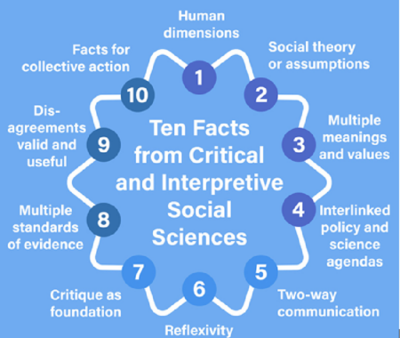
NEW PAPER: Ten facts from critical and interpretive social sciences for environmental research
4 July 2025The social sciences are crucial contributors to environmental research. Collectively, they provide insights on the economic, cultural, political, and psychological dimensions of sustainability challenges. Yet, efforts to mainstream the social sciences in environmental research are missing the diversity of social science scholarship. Here, we contend that the critical and interpretive social sciences —which question and […]
news -
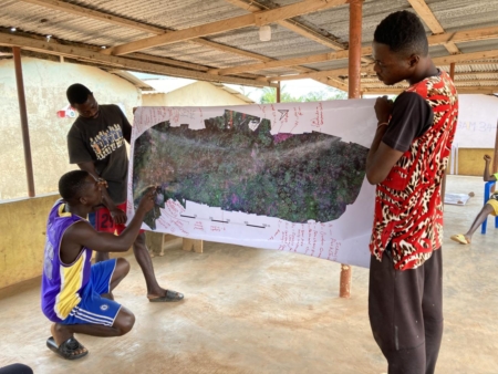
Beyond the Sensor: Building Blocks for Equitable Nature Recovery
6 January 2025Dr Eric Mensah Kumeh Remote sensing has been around for almost 150 years, with the earliest forms of remote sensing dating back to the 1800s. The first aerial photographs were taken in 1858 by Gaspard-Félix Tournachon, also known as Nadar, using a hot air balloon. Remote sensing is important because it provides a way to […]
news Blog -
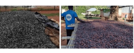
New publication: The political ecology of cocoa agroforestry and implications for equitable land use in rural Ghana.
12 August 2024The relevance of cocoa agroforestry is widely discussed in debates on sustainability transition in cocoa, especially in the context of ending hunger and poverty among cocoa farmers. Whereas this has led to multiple cocoa agroforestry investments by NGOs, governments, and cocoa and chocolate companies in West and Central Africa, a notable gap exists in the […]
news Scientific paper